Vol. 2, No 4, May 2002 (Drainit Times No. 2)
 In late March LIVING RIVERS completed a reconnaissance of the upper Colorado River arm at Lake Powell reservoir to further ascertain the gravity of the sediment build-up and delta formation at the head of the reservoir. With the reservoir at its lowest level in nine years, we were provided with a vivid picture of nature's progress toward forcing the decommissioning of the reservoir marinas, and ultimately Glen Canyon Dam.
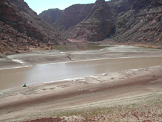
As anticipated, there was extensive sediment accumulation in both the main stem and side canyons. In many places the Colorado is cutting channels 25-foot deep, with perched segments calving off like glacier slabs along the Alaska coastline. River travel is difficult, as a minefield of sandbars and mudflats significantly complicate navigation through much of the main channel as it enters the reservoir.
An examination of the Dirty Devil River, one of the major tributaries flowing into the reservoir, revealed a ticking time bomb. Its river channel is completely full of stored sediment, a situation we observed in many of the side canyons. This suggests that a significant amount of sediment will be dumped beyond the suspended pile and into Hite Bay when strong summer storms resume on the Colorado Plateau.
There was also evidence of the river remobilizing sediment for transport toward the dam. With the reservoir level down 54 feet, the Colorado River has regained 30 miles of current, which is churning up and reworking the sediment down-reservoir. Because of new operating guidelines to store more Colorado River water in California, and cumulative poor snow packs in the headwaters, it will be difficult to keep Lake Powell reservoir full. The low reservoir levels will restore a flowing river over sediment, which will mobilize and quickly advance the delta and associated turbidity flows towards Glen Canyon Dam. Turbidity flows are the suspended sediments that continue flowing along the bottom of the reservoir and pile up before the front of the dam.
Currently the main delta sits about 150 miles from the dam, and less than one mile from Hite Marina. The deltaís advancement will soon force the closure of this marina, possibly as early as the end of this year. The sediment accumulation and reduced marina access will create problems for private and commercial river runners who end their Colorado River Cataract Canyon trips at Hite Marina. A similar situation already exists for river runners on the San Juan River arm of the reservoir. The San Juan delta is growing nearly as fast as the Colorado's, and has only about 100 miles to travel before reaching Glen Canyon Dam.
According to Dr. John Dohrenwend, a geomorphologist formerly with the US Geological Survey who took part in the expedition, reservoir and dam managers may be in for a shock. Similar to how BuRec planners misjudged the amount of water in the Colorado watershed, giving away 22% more water on paper than the river actually delivers, they may have misjudged the sedimentation rates too. Researchers have documented incredible cycles of erosion followed by deposition in the arroyos and rivers of the Colorado Plateau. In the 1880s, for example, a cycle of arroyo cutting and sediment movement began in the Southwest; this cycle ended in the early 1940s. Since then, there has been less erosion and more valley bottom deposition. "Thus," says Dohrenwend, "sedimentation in Lake Powell, from its creation to the present, occurred during a time of relatively slow landscape change that is not fully representative of historic times. Indeed, a return to the conditions that prevailed during the first half of the twentieth century would significantly accelerate sedimentation in Lake Powell and would significantly affect future use and operation of this reservoir."